


étang de botyre

suzanne.bron
User
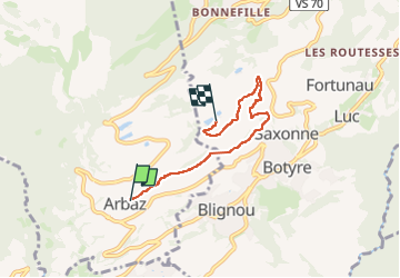

Length
4.6 km

Max alt
1229 m

Uphill gradient
177 m
Km-Effort
6.7 km

Min alt
1089 m

Downhill gradient
103 m
Boucle
No
Creation date :
2024-02-03 09:25:08.344
Updated on :
2024-02-03 11:20:51.317
1h45
Difficulty : Medium

FREE GPS app for hiking
 SityTrail
IGN / Geographical institutes
SityTrail Plus
The world is yours!
About
Trail Walking of 4.6 km to be discovered at Valais/Wallis, Sion, Arbaz. This trail is proposed by suzanne.bron.
Photos

Positioning
Country:
Switzerland
Region :
Valais/Wallis
Department/Province :
Sion
Municipality :
Arbaz
Location:
Unknown
Start:(Dec)
Start:(UTM)
375520 ; 5125714 (32T) N.
Comments