


Trail Ahuy 03/02/24

Fab-Oz
User
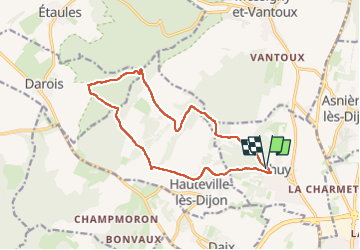

Length
13.9 km

Max alt
456 m

Uphill gradient
373 m
Km-Effort
18.9 km

Min alt
294 m

Downhill gradient
380 m
Boucle
Yes
Creation date :
2024-02-03 10:11:16.166
Updated on :
2024-02-03 12:06:31.509
1h45
Difficulty : Easy

FREE GPS app for hiking
 SityTrail
IGN / Geographical institutes
SityTrail Plus
The world is yours!
About
Trail Trail of 13.9 km to be discovered at Bourgogne-Franche-Comté, Côte-d'Or, Ahuy. This trail is proposed by Fab-Oz.
Description
Bouble au départ d'Ahuy
Positioning
Country:
France
Region :
Bourgogne-Franche-Comté
Department/Province :
Côte-d'Or
Municipality :
Ahuy
Location:
Unknown
Start:(Dec)
Start:(UTM)
652206 ; 5248287 (31T) N.
Comments