


Le gardot

dcharbonnier
User
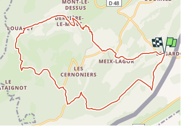

Length
12.5 km

Max alt
1183 m

Uphill gradient
450 m
Km-Effort
18.5 km

Min alt
826 m

Downhill gradient
449 m
Boucle
Yes
Creation date :
2024-02-03 13:34:08.0
Updated on :
2024-02-03 13:34:09.373
4h13
Difficulty : Medium

FREE GPS app for hiking
 SityTrail
IGN / Geographical institutes
SityTrail Plus
The world is yours!
About
Trail Walking of 12.5 km to be discovered at Bourgogne-Franche-Comté, Doubs, Montlebon. This trail is proposed by dcharbonnier.
Description
Rando pédestre.
Positioning
Country:
France
Region :
Bourgogne-Franche-Comté
Department/Province :
Doubs
Municipality :
Montlebon
Location:
Unknown
Start:(Dec)
Start:(UTM)
320905 ; 5209231 (32T) N.
Comments