


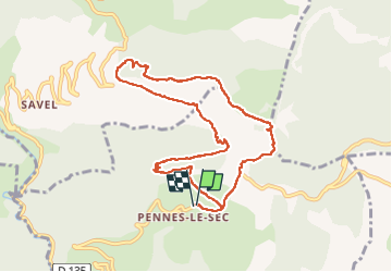
PENNES 01 2024

nordan
User

Length
9.9 km

Max alt
1321 m

Uphill gradient
759 m
Km-Effort
20 km

Min alt
817 m

Downhill gradient
761 m
Boucle
Yes
Creation date :
2024-02-03 08:34:53.21
Updated on :
2024-02-03 14:51:24.383
3h36
Difficulty : Very difficult

FREE GPS app for hiking
 SityTrail
IGN / Geographical institutes
SityTrail Plus
The world is yours!
About
Trail Walking of 9.9 km to be discovered at Auvergne-Rhône-Alpes, Drôme, Pennes-le-Sec. This trail is proposed by nordan.
Positioning
Country:
France
Region :
Auvergne-Rhône-Alpes
Department/Province :
Drôme
Municipality :
Pennes-le-Sec
Location:
Unknown
Start:(Dec)
Start:(UTM)
683933 ; 4945458 (31T) N.
Comments