


Trace Vignec les Loulous Guy

mitch1952
User
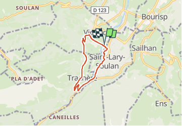

Length
4.9 km

Max alt
948 m

Uphill gradient
139 m
Km-Effort
6.8 km

Min alt
810 m

Downhill gradient
141 m
Boucle
Yes
Creation date :
2024-02-03 14:07:56.0
Updated on :
2024-02-03 15:32:26.267

FREE GPS app for hiking
 SityTrail
IGN / Geographical institutes
SityTrail Plus
The world is yours!
About
Trail of 4.9 km to be discovered at Occitania, Hautespyrenees, Vignec. This trail is proposed by mitch1952.
Positioning
Country:
France
Region :
Occitania
Department/Province :
Hautespyrenees
Municipality :
Vignec
Location:
Unknown
Start:(Dec)
Start:(UTM)
281006 ; 4744432 (31T) N.
Comments