


saou chemin des muletiers

Gilbertbancilhon
User
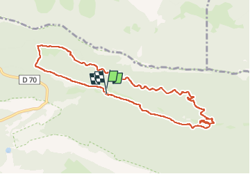

Length
10.5 km

Max alt
656 m

Uphill gradient
310 m
Km-Effort
14.6 km

Min alt
399 m

Downhill gradient
310 m
Boucle
Yes
Creation date :
2024-02-03 10:00:11.928
Updated on :
2024-02-03 15:35:27.608
4h29
Difficulty : Difficult

FREE GPS app for hiking
 SityTrail
IGN / Geographical institutes
SityTrail Plus
The world is yours!
About
Trail Walking of 10.5 km to be discovered at Auvergne-Rhône-Alpes, Drôme, Saou. This trail is proposed by Gilbertbancilhon.
Positioning
Country:
France
Region :
Auvergne-Rhône-Alpes
Department/Province :
Drôme
Municipality :
Saou
Location:
Unknown
Start:(Dec)
Start:(UTM)
667307 ; 4946991 (31T) N.
Comments