Trail Walking Parignargues - Parignargues_ST_Mamert_Fons_Gagan - Photo

Parignargues_ST_Mamert_Fons_Gagan

 v.rabot
v.rabot

User

© OpenStreetMap contributors
Length
Length
14.4 km
Max alt
Max alt
164 m
Uphill gradient
Uphill gradient
144 m
Km-Effort
Km-Effort  
16.3 km
Min alt
Min alt
90 m
Downhill gradient
Downhill gradient
145 m
Boucle
Boucle
Yes
Creation date :
2024-02-03 10:23:47.453
Updated on :
2024-02-03 19:23:11.736

(0 Reviews)

Walking
Walking
4h46
Difficulty : Medium

Scan this QR Code to open this trail in the SityTrail application

FREE GPS app for hiking

Logo SityTrail SityTrail

IGN / Geographical institutes

Download SityTrail from the App Store Download SityTrail from Google Play

Logo SityTrail SityTrail World

The world is yours!

Download SityTrail from the App Store Download SityTrail from Google Play Download SityTrail on Huawei AppGallery

About

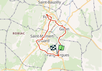
Trail Walking of 14.4 km to be discovered at Occitania, Gard, Parignargues. This trail is proposed by v.rabot.

Description

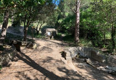
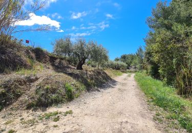
Partant de Parignargues, on passe près du temple , on traverse les champs  pour se rendre à Saint Mamert, ou on trouvera quelques repères des différents points clés du village, on admirera aussi le chêne de la liberté planté en 1918 et ayant donc 106ans. Puis on rejoint Fons par un chemin en partie ombragé et on y découvre une belle école avec une porte pour les filles et les garçons, l'église a été rénovée et la maison, ou Alphonse Daudet a vécu une partie de son enfance chez sa nourrice,  est sise à coté, passez dans les toutes petites  ruelles,A Gagan, vous admirerez le lavoir,  la porte de France puis passage sur le chemin des moulins pour rejoindre Parignargues ou vous pourrez voir la magnanerie à côté du lavoir, le four, l'église et l'ancienne adduction d'eau et son abreuvoir près du temple. Aucune difficulté sur ce parcours qu'il faut sans doute éviter en plein été, il n'est pas nécessaire de prendre des bâtons.

Elevation profile

Photos

35 photos in total. Please click on a photo to see them all in the gallery.

Positioning

Country:
France
Region :
Occitania
Department/Province :
Gard
Municipality :
Parignargues
Location:
Unknown
Start:(UTM)
596977 ; 4858636 (31T) N.

Trails nearby

Trail Walking Gajan - Rando1 - Photo
Walking
selleck

Walking

Medium
(1)
Gajan, Occitania, Gard, France
10 km | 12.2 km-effort
2h 0min
Yes
Trail Walking Gajan - Plan Rougé2 - Photo
Walking
selleck

Walking

Easy
(1)
Gajan, Occitania, Gard, France
10.9 km | 13.4 km-effort
2h 53min
Yes
Trail Walking Gajan - Mas des Crottes - Photo
Walking
selleck

Walking

Easy
(1)
Gajan, Occitania, Gard, France
13.1 km | 15.7 km-effort
3h 34min
Yes
Trail Walking Gajan - La Rouveyrolle 2 - Photo
Walking
selleck

Walking

Medium
(1)
Gajan, Occitania, Gard, France
12.5 km | 15.2 km-effort
2h 37min
Yes
Trail Walking Parignargues - Parignargues_stmamert-Fons-Gajan - Photo
Walking
v.rabot

Walking

Medium
Parignargues, Occitania, Gard, France
16.4 km | 18.6 km-effort
5h 19min
Yes
Trail Walking Gajan - GAJAN / FONS / ST MAMERT / GAJAN - Photo
Walking
jll7513

Walking

Medium
Gajan, Occitania, Gard, France
9.9 km | 11.6 km-effort
2h 36min
Yes
Trail Walking Clarensac - Clarensac et les fermes voltaïques. - Photo
Walking
jll7513

Walking

Difficult
Clarensac, Occitania, Gard, France
11 km | 13.5 km-effort
3h 4min
Yes
Trail Walking Clarensac - Clarensac - Photo
Walking
v.rabot

Walking

Difficult
Clarensac, Occitania, Gard, France
13.7 km | 16.6 km-effort
3h 28min
Yes
Trail Walking Fons - Fons Ouest 6 kms - Photo
Walking
PEDAROUX

Walking

Medium
(1)
Fons, Occitania, Gard, France
5.9 km | 7.4 km-effort
40min
Yes


Close
My subscriptions