


Autour de Tardinghem

mathis01
User
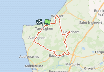

Length
24 km

Max alt
119 m

Uphill gradient
277 m
Km-Effort
28 km

Min alt
5 m

Downhill gradient
274 m
Boucle
Yes
Creation date :
2024-02-04 07:43:57.681
Updated on :
2024-02-04 08:10:47.407
6h26
Difficulty : Medium
1h25
Difficulty : Medium

FREE GPS app for hiking
 SityTrail
IGN / Geographical institutes
SityTrail Plus
The world is yours!
About
Trail On foot of 24 km to be discovered at Hauts-de-France, Pas-de-Calais, Tardinghen. This trail is proposed by mathis01.
Positioning
Country:
France
Region :
Hauts-de-France
Department/Province :
Pas-de-Calais
Municipality :
Tardinghen
Location:
Unknown
Start:(Dec)
Start:(UTM)
403560 ; 5635872 (31U) N.
Comments