


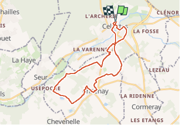
Cellettes

Pascal Bernaud
User

Length
15.9 km

Max alt
100 m

Uphill gradient
135 m
Km-Effort
17.6 km

Min alt
70 m

Downhill gradient
134 m
Boucle
Yes
Creation date :
2024-02-04 06:54:05.0
Updated on :
2024-02-04 10:07:21.147
3h12
Difficulty : Difficult

FREE GPS app for hiking
 SityTrail
IGN / Geographical institutes
SityTrail Plus
The world is yours!
About
Trail Walking of 15.9 km to be discovered at Centre-Loire Valley, Loir-et-Cher, Cellettes. This trail is proposed by Pascal Bernaud.
Positioning
Country:
France
Region :
Centre-Loire Valley
Department/Province :
Loir-et-Cher
Municipality :
Cellettes
Location:
Unknown
Start:(Dec)
Start:(UTM)
378483 ; 5265347 (31T) N.
Comments