


Mas de Londres - le Pic St Loup du 05-02-2024

VANDERPUTTENMi
User GUIDE
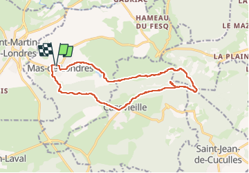

Length
16.7 km

Max alt
645 m

Uphill gradient
621 m
Km-Effort
25 km

Min alt
196 m

Downhill gradient
621 m
Boucle
Yes
Creation date :
2024-02-04 07:42:19.556
Updated on :
2024-02-05 18:01:57.636
5h40
Difficulty : Very difficult

FREE GPS app for hiking
 SityTrail
IGN / Geographical institutes
SityTrail Plus
The world is yours!
About
Trail Walking of 16.7 km to be discovered at Occitania, Hérault, Mas-de-Londres. This trail is proposed by VANDERPUTTENMi.
Photos


Positioning
Country:
France
Region :
Occitania
Department/Province :
Hérault
Municipality :
Mas-de-Londres
Location:
Unknown
Start:(Dec)
Start:(UTM)
560739 ; 4848233 (31T) N.
Comments