


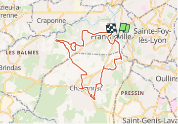
Aqueduc et fort du Bruissin (PR1)

chuck
User

Length
19.1 km

Max alt
333 m

Uphill gradient
328 m
Km-Effort
23 km

Min alt
219 m

Downhill gradient
328 m
Boucle
Yes
Creation date :
2024-02-04 09:38:31.489
Updated on :
2024-02-04 18:01:14.692
5h20
Difficulty : Easy

FREE GPS app for hiking
 SityTrail
IGN / Geographical institutes
SityTrail Plus
The world is yours!
About
Trail Walking of 19.1 km to be discovered at Auvergne-Rhône-Alpes, Métropole de Lyon, Francheville. This trail is proposed by chuck.
Description
Topo les environs de Lyon à pied
Photos
 - Photo 1")
 - Photo 2")
 - Photo 3")
Positioning
Country:
France
Region :
Auvergne-Rhône-Alpes
Department/Province :
Métropole de Lyon
Municipality :
Francheville
Location:
Unknown
Start:(Dec)
Start:(UTM)
637665 ; 5066062 (31T) N.
Comments