


sur la trace des anciens chemins

Mascart
User

Length
8.1 km

Max alt
494 m

Uphill gradient
131 m
Km-Effort
10 km

Min alt
350 m

Downhill gradient
183 m
Boucle
No
Creation date :
2024-02-04 13:22:50.054
Updated on :
2024-02-04 16:22:36.31
2h24
Difficulty : Easy

FREE GPS app for hiking
 SityTrail
IGN / Geographical institutes
SityTrail Plus
The world is yours!
About
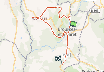
Trail Walking of 8.1 km to be discovered at Occitania, Aude, Brousses-et-Villaret. This trail is proposed by Mascart.
Description
BrouSses et Villaret
Positioning
Country:
France
Region :
Occitania
Department/Province :
Aude
Municipality :
Brousses-et-Villaret
Location:
Unknown
Start:(Dec)
Start:(UTM)
439586 ; 4799246 (31T) N.
Comments