


labeil m'as caylar

lablaquiere
User
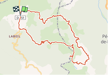

Length
14.1 km

Max alt
762 m

Uphill gradient
324 m
Km-Effort
18.4 km

Min alt
632 m

Downhill gradient
324 m
Boucle
Yes
Creation date :
2024-02-04 12:24:43.846
Updated on :
2024-02-04 17:07:09.469
3h42
Difficulty : Difficult

FREE GPS app for hiking
 SityTrail
IGN / Geographical institutes
SityTrail Plus
The world is yours!
About
Trail Walking of 14.1 km to be discovered at Occitania, Hérault, Lauroux. This trail is proposed by lablaquiere.
Positioning
Country:
France
Region :
Occitania
Department/Province :
Hérault
Municipality :
Lauroux
Location:
Unknown
Start:(Dec)
Start:(UTM)
521670 ; 4851039 (31T) N.
Comments