


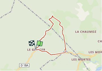
Le Glacier

Genisset
User

Length
5.7 km

Max alt
1123 m

Uphill gradient
108 m
Km-Effort
7.1 km

Min alt
1072 m

Downhill gradient
111 m
Boucle
Yes
Creation date :
2024-02-03 13:09:32.168
Updated on :
2024-02-06 15:41:28.16
1h13
Difficulty : Medium

FREE GPS app for hiking
 SityTrail
IGN / Geographical institutes
SityTrail Plus
The world is yours!
About
Trail Walking of 5.7 km to be discovered at Bourgogne-Franche-Comté, Jura, Morbier. This trail is proposed by Genisset.
Positioning
Country:
France
Region :
Bourgogne-Franche-Comté
Department/Province :
Jura
Municipality :
Morbier
Location:
Unknown
Start:(Dec)
Start:(UTM)
274814 ; 5163387 (32T) N.
Comments