


Dimanche-des-pietons-12-2011(2h00)

JackPG
User
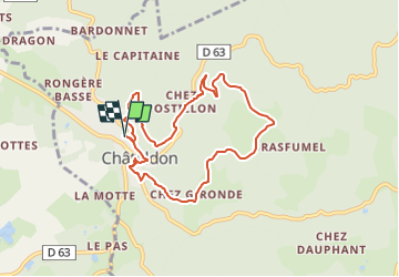

Length
7.9 km

Max alt
519 m

Uphill gradient
304 m
Km-Effort
12 km

Min alt
306 m

Downhill gradient
304 m
Boucle
Yes
Creation date :
2024-02-07 05:41:25.152
Updated on :
2024-02-27 06:21:40.936
2h43
Difficulty : Medium

FREE GPS app for hiking
 SityTrail
IGN / Geographical institutes
SityTrail Plus
The world is yours!
About
Trail Walking of 7.9 km to be discovered at Auvergne-Rhône-Alpes, Puy-de-Dôme, Châteldon. This trail is proposed by JackPG.

Positioning
Country:
France
Region :
Auvergne-Rhône-Alpes
Department/Province :
Puy-de-Dôme
Municipality :
Châteldon
Location:
Unknown
Start:(Dec)
Start:(UTM)
540170 ; 5091856 (31T) N.
Comments