Trail Horseback riding Belmont - Chemin Chateaux 08 Belmont StPierre - Photo

Chemin Chateaux 08 Belmont StPierre

Promouvoir le Tourisme Equestre en Alsace GUIDE+
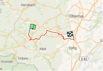
© OpenStreetMap contributors
Length
Length
27 km
Max alt
Max alt
1046 m
Uphill gradient
Uphill gradient
424 m
Km-Effort
Km-Effort  
36 km
Min alt
Min alt
177 m
Downhill gradient
Downhill gradient
1247 m
Boucle
Boucle
No
Creation date :
2024-02-07 10:51:40.337
Updated on :
2024-02-12 09:35:27.667

(0 Reviews)

Horseback riding
Horseback riding
4h41
Difficulty : Medium

Scan this QR Code to open this trail in the SityTrail application

FREE GPS app for hiking

Logo SityTrail SityTrail

IGN / Geographical institutes

Download SityTrail from the App Store Download SityTrail from Google Play

Logo SityTrail SityTrail Plus

The world is yours!

Download SityTrail from the App Store Download SityTrail from Google Play Download SityTrail on Huawei AppGallery

About

Trail Horseback riding of 27 km to be discovered at Grand Est, Bas-Rhin, Belmont. This trail is proposed by Tourisme Equestre Alsace.

Elevation profile

Photos

Points of interest

Point of interest Breitenbach - Auberge de la Charbonniere - Photo
Tourisme Equestre Alsace
Point of interest Andlau - Auberge du Hungerplatz - Photo
Tourisme Equestre Alsace
Point of interest Andlau - CirVC Abreuvoir possible - Photo
Tourisme Equestre Alsace
Point of interest Andlau - Spesbourg - Incontournable - Photo
Tourisme Equestre Alsace
Point of interest Andlau - Andlau - Incontournable - Photo
Tourisme Equestre Alsace
Point of interest Mittelbergheim - CirVC Passage par les pres si possible - Photo
Tourisme Equestre Alsace

Positioning

Country:
France
Region :
Grand Est
Department/Province :
Bas-Rhin
Municipality :
Belmont
Location:
Unknown
Start:(UTM)
370742 ; 5363095 (32U) N.


Close
My subscriptions