


Le col du Bougnon

GeorgesV.
User
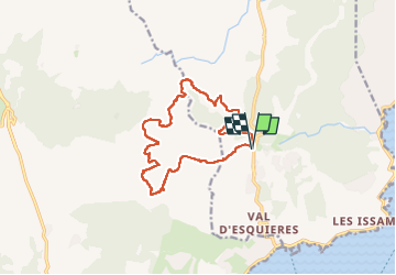

Length
14.3 km

Max alt
343 m

Uphill gradient
792 m
Km-Effort
25 km

Min alt
81 m

Downhill gradient
791 m
Boucle
Yes
Creation date :
2024-02-07 07:01:22.0
Updated on :
2024-02-07 21:53:14.789

FREE GPS app for hiking
 SityTrail
IGN / Geographical institutes
SityTrail Plus
The world is yours!
About
Trail of 14.3 km to be discovered at Provence-Alpes-Côte d'Azur, Var, Roquebrune-sur-Argens. This trail is proposed by GeorgesV..
Positioning
Country:
France
Region :
Provence-Alpes-Côte d'Azur
Department/Province :
Var
Municipality :
Roquebrune-sur-Argens
Location:
Unknown
Start:(Dec)
Start:(UTM)
311449 ; 4803809 (32T) N.
Comments