


sain bel

vaud
User
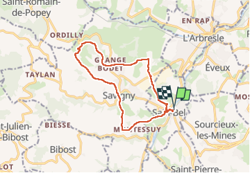

Length
13.3 km

Max alt
479 m

Uphill gradient
386 m
Km-Effort
18.5 km

Min alt
240 m

Downhill gradient
386 m
Boucle
Yes
Creation date :
2024-02-07 09:32:47.47
Updated on :
2024-02-07 14:38:21.848
3h49
Difficulty : Medium

FREE GPS app for hiking
 SityTrail
IGN / Geographical institutes
SityTrail Plus
The world is yours!
About
Trail Walking of 13.3 km to be discovered at Auvergne-Rhône-Alpes, Rhône, Sain-Bel. This trail is proposed by vaud.
Positioning
Country:
France
Region :
Auvergne-Rhône-Alpes
Department/Province :
Rhône
Municipality :
Sain-Bel
Location:
Unknown
Start:(Dec)
Start:(UTM)
624461 ; 5074348 (31T) N.
Comments