


Hauts d'Ax

crognon
User
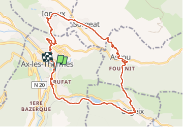

Length
13.2 km

Max alt
1062 m

Uphill gradient
458 m
Km-Effort
19.3 km

Min alt
713 m

Downhill gradient
459 m
Boucle
Yes
Creation date :
2024-02-07 09:03:26.674
Updated on :
2024-02-07 15:35:29.833
6h31
Difficulty : Medium

FREE GPS app for hiking
 SityTrail
IGN / Geographical institutes
SityTrail Plus
The world is yours!
About
Trail Walking of 13.2 km to be discovered at Occitania, Ariège, Ax-les-Thermes. This trail is proposed by crognon.
Positioning
Country:
France
Region :
Occitania
Department/Province :
Ariège
Municipality :
Ax-les-Thermes
Location:
Unknown
Start:(Dec)
Start:(UTM)
405070 ; 4730097 (31T) N.
Comments