


2024-02-07_22h30m09_B3

LUTZMarc
User
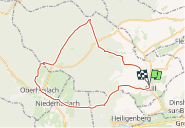

Length
16.8 km

Max alt
387 m

Uphill gradient
370 m
Km-Effort
22 km

Min alt
210 m

Downhill gradient
371 m
Boucle
Yes
Creation date :
2024-02-07 21:30:09.531
Updated on :
2024-11-01 08:43:08.5
4h56
Difficulty : Medium

FREE GPS app for hiking
 SityTrail
IGN / Geographical institutes
SityTrail Plus
The world is yours!
About
Trail Walking of 16.8 km to be discovered at Grand Est, Bas-Rhin, Still. This trail is proposed by LUTZMarc.
Description
Resto Le saint Florent à Oberhaslach
Positioning
Country:
France
Region :
Grand Est
Department/Province :
Bas-Rhin
Municipality :
Still
Location:
Unknown
Start:(Dec)
Start:(UTM)
382147 ; 5378906 (32U) N.
Comments