


Hurtières

MICDURAND
User
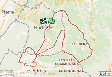

Length
13 km

Max alt
1054 m

Uphill gradient
542 m
Km-Effort
20 km

Min alt
736 m

Downhill gradient
538 m
Boucle
Yes
Creation date :
2024-02-08 08:29:40.956
Updated on :
2024-02-08 13:32:29.944
3h46
Difficulty : Easy

FREE GPS app for hiking
 SityTrail
IGN / Geographical institutes
SityTrail Plus
The world is yours!
About
Trail Walking of 13 km to be discovered at Auvergne-Rhône-Alpes, Isère. This trail is proposed by MICDURAND.
Positioning
Country:
France
Region :
Auvergne-Rhône-Alpes
Department/Province :
Isère
Municipality :
Unknown
Location:
Unknown
Start:(Dec)
Start:(UTM)
732993 ; 5019231 (31T) N.
Comments