


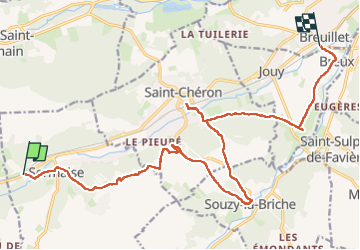
De Sermaise à Breuillet (91)

Chabard
User

Length
18.4 km

Max alt
158 m

Uphill gradient
334 m
Km-Effort
23 km

Min alt
56 m

Downhill gradient
364 m
Boucle
No
Creation date :
2024-02-08 08:19:39.0
Updated on :
2024-02-08 18:42:14.887
5h13
Difficulty : Very difficult

FREE GPS app for hiking
 SityTrail
IGN / Geographical institutes
SityTrail Plus
The world is yours!
About
Trail Walking of 18.4 km to be discovered at Ile-de-France, Essonne, Sermaise. This trail is proposed by Chabard.
Description
Randonnée de la gare de Sermaise à la gare de Breuillet avec une escale déjeuner à la gare de Saint-Chéron
Positioning
Country:
France
Region :
Ile-de-France
Department/Province :
Essonne
Municipality :
Sermaise
Location:
Unknown
Start:(Dec)
Start:(UTM)
431309 ; 5376243 (31U) N.
Comments