


autour de Derrière-Le-Mont.

dcharbonnier
User
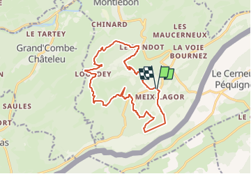

Length
15.8 km

Max alt
1185 m

Uphill gradient
610 m
Km-Effort
24 km

Min alt
815 m

Downhill gradient
611 m
Boucle
Yes
Creation date :
2024-02-09 19:11:18.738
Updated on :
2024-02-09 19:11:20.924
5h27
Difficulty : Difficult

FREE GPS app for hiking
 SityTrail
IGN / Geographical institutes
SityTrail Plus
The world is yours!
About
Trail Walking of 15.8 km to be discovered at Bourgogne-Franche-Comté, Doubs, Montlebon. This trail is proposed by dcharbonnier.
Description
difficile notamment en raison des chemins de la première partie. conseil ne pas franchir la première crête.
Positioning
Country:
France
Region :
Bourgogne-Franche-Comté
Department/Province :
Doubs
Municipality :
Montlebon
Location:
Unknown
Start:(Dec)
Start:(UTM)
319561 ; 5209373 (32T) N.
Comments