


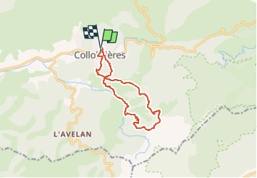
Trail des Menhirs 12 KM

jpb83
User

Length
12 km

Max alt
517 m

Uphill gradient
538 m
Km-Effort
19.2 km

Min alt
152 m

Downhill gradient
523 m
Boucle
Yes
Creation date :
2024-02-10 21:55:41.34
Updated on :
2024-02-10 21:56:54.934
0m
Difficulty : Difficult

FREE GPS app for hiking
 SityTrail
IGN / Geographical institutes
SityTrail Plus
The world is yours!
About
Trail Trail of 12 km to be discovered at Provence-Alpes-Côte d'Azur, Var, Collobrières. This trail is proposed by jpb83.
Positioning
Country:
France
Region :
Provence-Alpes-Côte d'Azur
Department/Province :
Var
Municipality :
Collobrières
Location:
Unknown
Start:(Dec)
Start:(UTM)
281513 ; 4790802 (32T) N.
Comments