


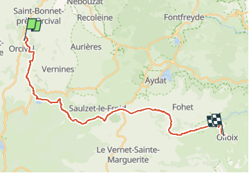
La croix Orcival . Lac Servière . Saulzet le F . Olloix

Pierre Dabin
User

Length
27 km

Max alt
1224 m

Uphill gradient
631 m
Km-Effort
36 km

Min alt
725 m

Downhill gradient
696 m
Boucle
No
Creation date :
2024-02-12 16:07:26.467
Updated on :
2024-03-07 20:15:57.594
4h44
Difficulty : Difficult

FREE GPS app for hiking
 SityTrail
IGN / Geographical institutes
SityTrail Plus
The world is yours!
About
Trail Horseback riding of 27 km to be discovered at Auvergne-Rhône-Alpes, Puy-de-Dôme, Orcival. This trail is proposed by Pierre Dabin.
Description
Passage par le Lac Serviéres et la vallée de la Mone .
Positioning
Country:
France
Region :
Auvergne-Rhône-Alpes
Department/Province :
Puy-de-Dôme
Municipality :
Orcival
Location:
Unknown
Start:(Dec)
Start:(UTM)
487930 ; 5059430 (31T) N.
Comments