


Eguilles Francisco 12 février 2024

rlebasque
User

Length
11.4 km

Max alt
309 m

Uphill gradient
197 m
Km-Effort
14 km

Min alt
225 m

Downhill gradient
196 m
Boucle
Yes
Creation date :
2024-02-12 12:39:26.733
Updated on :
2024-02-12 16:07:44.678
3h26
Difficulty : Difficult

FREE GPS app for hiking
 SityTrail
IGN / Geographical institutes
SityTrail Plus
The world is yours!
About
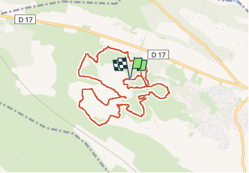
Trail Walking of 11.4 km to be discovered at Provence-Alpes-Côte d'Azur, Bouches-du-Rhône, Éguilles. This trail is proposed by rlebasque.
Positioning
Country:
France
Region :
Provence-Alpes-Côte d'Azur
Department/Province :
Bouches-du-Rhône
Municipality :
Éguilles
Location:
Unknown
Start:(Dec)
Start:(UTM)
687038 ; 4827523 (31T) N.
Comments