


stevenson2

ARVIEU
User
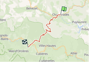

Length
17.4 km

Max alt
1415 m

Uphill gradient
520 m
Km-Effort
25 km

Min alt
1063 m

Downhill gradient
625 m
Boucle
No
Creation date :
2024-02-12 17:45:22.469
Updated on :
2024-02-12 17:46:26.974
5h00
Difficulty : Medium

FREE GPS app for hiking
 SityTrail
IGN / Geographical institutes
SityTrail Plus
The world is yours!
About
Trail Walking of 17.4 km to be discovered at Occitania, Lozère, Mont Lozère et Goulet. This trail is proposed by ARVIEU.
Positioning
Country:
France
Region :
Occitania
Department/Province :
Lozère
Municipality :
Mont Lozère et Goulet
Location:
Unknown
Start:(Dec)
Start:(UTM)
565531 ; 4933466 (31T) N.
Comments