


forca

Orres
User
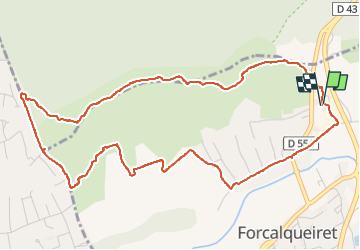

Length
6.4 km

Max alt
444 m

Uphill gradient
177 m
Km-Effort
8.8 km

Min alt
294 m

Downhill gradient
174 m
Boucle
Yes
Creation date :
2024-02-13 07:49:32.204
Updated on :
2024-02-13 10:03:27.872
1h44
Difficulty : Medium

FREE GPS app for hiking
 SityTrail
IGN / Geographical institutes
SityTrail Plus
The world is yours!
About
Trail Walking of 6.4 km to be discovered at Provence-Alpes-Côte d'Azur, Var, Forcalqueiret. This trail is proposed by Orres.
Positioning
Country:
France
Region :
Provence-Alpes-Côte d'Azur
Department/Province :
Var
Municipality :
Forcalqueiret
Location:
Unknown
Start:(Dec)
Start:(UTM)
263785 ; 4803343 (32T) N.
Comments