


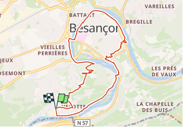
Un tour à Besançon

dcharbonnier
User

Length
10.2 km

Max alt
414 m

Uphill gradient
330 m
Km-Effort
14.6 km

Min alt
233 m

Downhill gradient
326 m
Boucle
Yes
Creation date :
2024-02-13 15:43:48.0
Updated on :
2024-02-13 15:43:49.644
3h18
Difficulty : Difficult

FREE GPS app for hiking
 SityTrail
IGN / Geographical institutes
SityTrail Plus
The world is yours!
About
Trail Walking of 10.2 km to be discovered at Bourgogne-Franche-Comté, Doubs, Besançon. This trail is proposed by dcharbonnier.
Description
Depuis Velote, Citadelle et boucle. Retour par Chaudane.
Positioning
Country:
France
Region :
Bourgogne-Franche-Comté
Department/Province :
Doubs
Municipality :
Besançon
Location:
Unknown
Start:(Dec)
Start:(UTM)
273708 ; 5233847 (32T) N.
Comments