


balade avec les chiens 12 mars 2015

pconte
User
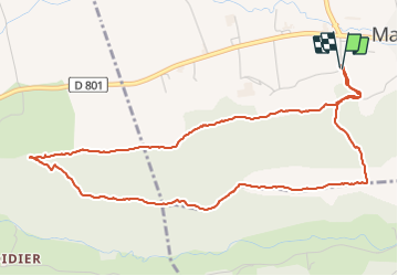

Length
6.1 km

Max alt
437 m

Uphill gradient
154 m
Km-Effort
8.1 km

Min alt
310 m

Downhill gradient
155 m
Boucle
Yes
Creation date :
2015-03-12 00:00:00.0
Updated on :
2015-03-12 00:00:00.0
1h35
Difficulty : Unknown

FREE GPS app for hiking
 SityTrail
IGN / Geographical institutes
SityTrail Plus
The world is yours!
About
Trail Walking of 6.1 km to be discovered at Auvergne-Rhône-Alpes, Isère, Marcollin. This trail is proposed by pconte.
Positioning
Country:
France
Region :
Auvergne-Rhône-Alpes
Department/Province :
Isère
Municipality :
Marcollin
Location:
Unknown
Start:(Dec)
Start:(UTM)
663206 ; 5018731 (31T) N.
Comments