


boucle Beauvais 2

reflexe
User
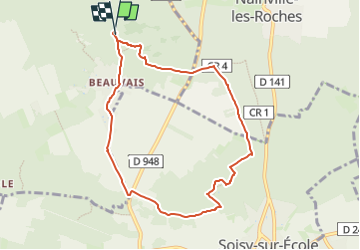

Length
7.8 km

Max alt
128 m

Uphill gradient
110 m
Km-Effort
9.3 km

Min alt
78 m

Downhill gradient
111 m
Boucle
Yes
Creation date :
2024-02-14 10:23:36.35
Updated on :
2024-02-14 10:26:43.067
2h06
Difficulty : Medium

FREE GPS app for hiking
 SityTrail
IGN / Geographical institutes
SityTrail Plus
The world is yours!
About
Trail Walking of 7.8 km to be discovered at Ile-de-France, Essonne, Champcueil. This trail is proposed by reflexe.
Description
boucle
Positioning
Country:
France
Region :
Ile-de-France
Department/Province :
Essonne
Municipality :
Champcueil
Location:
Unknown
Start:(Dec)
Start:(UTM)
460742 ; 5372328 (31U) N.
Comments