


koebrug

karlaenjo
User
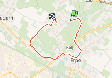

Length
3 km

Max alt
27 m

Uphill gradient
21 m
Km-Effort
3.3 km

Min alt
14 m

Downhill gradient
17 m
Boucle
No
Creation date :
2024-02-14 09:36:48.499
Updated on :
2024-02-14 10:26:26.428
49m
Difficulty : Easy

FREE GPS app for hiking
 SityTrail
IGN / Geographical institutes
SityTrail Plus
The world is yours!
About
Trail Walking of 3 km to be discovered at Flanders, East Flanders, Erpe-Mere. This trail is proposed by karlaenjo.
Description
via koebrug, dorpstraat, kraainest en kruiskes.
Positioning
Country:
Belgium
Region :
Flanders
Department/Province :
East Flanders
Municipality :
Erpe-Mere
Location:
Erpe
Start:(Dec)
Start:(UTM)
568512 ; 5643639 (31U) N.
Comments