


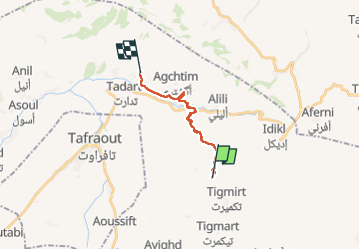
14 fév rando vers Oumesmat

michcoq
User

Length
14.7 km

Max alt
1362 m

Uphill gradient
240 m
Km-Effort
18.7 km

Min alt
992 m

Downhill gradient
469 m
Boucle
No
Creation date :
2024-02-14 08:36:29.292
Updated on :
2024-02-25 09:44:41.432
6h31
Difficulty : Difficult

FREE GPS app for hiking
 SityTrail
IGN / Geographical institutes
SityTrail Plus
The world is yours!
About
Trail Walking of 14.7 km to be discovered at Souss-Massa, cercle de Tafraout, Ammelne. This trail is proposed by michcoq.
Positioning
Country:
Morocco
Region :
Souss-Massa
Department/Province :
cercle de Tafraout
Municipality :
Ammelne
Location:
Unknown
Start:(Dec)
Start:(UTM)
510288 ; 3285753 (29R) N.
Comments