


Ponteves Flassans

aljac
User
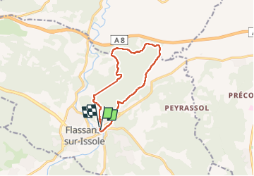

Length
11.8 km

Max alt
318 m

Uphill gradient
297 m
Km-Effort
15.7 km

Min alt
215 m

Downhill gradient
291 m
Boucle
Yes
Creation date :
2024-02-15 08:58:20.845
Updated on :
2024-02-15 13:49:54.891
4h51
Difficulty : Easy

FREE GPS app for hiking
 SityTrail
IGN / Geographical institutes
SityTrail Plus
The world is yours!
About
Trail Walking of 11.8 km to be discovered at Provence-Alpes-Côte d'Azur, Var, Flassans-sur-Issole. This trail is proposed by aljac.
Positioning
Country:
France
Region :
Provence-Alpes-Côte d'Azur
Department/Province :
Var
Municipality :
Flassans-sur-Issole
Location:
Unknown
Start:(Dec)
Start:(UTM)
274919 ; 4805644 (32T) N.
Comments