


Plan de Baix 15 02 24

nordan
User
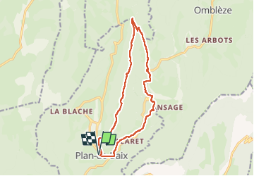

Length
14.8 km

Max alt
1018 m

Uphill gradient
651 m
Km-Effort
23 km

Min alt
536 m

Downhill gradient
651 m
Boucle
Yes
Creation date :
2024-02-15 09:35:01.494
Updated on :
2024-02-15 14:13:10.401
3h46
Difficulty : Medium

FREE GPS app for hiking
 SityTrail
IGN / Geographical institutes
SityTrail Plus
The world is yours!
About
Trail Walking of 14.8 km to be discovered at Auvergne-Rhône-Alpes, Drôme, Plan-de-Baix. This trail is proposed by nordan.
Positioning
Country:
France
Region :
Auvergne-Rhône-Alpes
Department/Province :
Drôme
Municipality :
Plan-de-Baix
Location:
Unknown
Start:(Dec)
Start:(UTM)
671162 ; 4964459 (31T) N.
Comments