


Mercuer

Rudy07
User
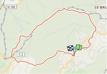

Length
5.7 km

Max alt
520 m

Uphill gradient
247 m
Km-Effort
9 km

Min alt
296 m

Downhill gradient
249 m
Boucle
Yes
Creation date :
2024-02-15 16:21:59.65
Updated on :
2024-03-09 13:47:32.531
2h02
Difficulty : Medium

FREE GPS app for hiking
 SityTrail
IGN / Geographical institutes
SityTrail Plus
The world is yours!
About
Trail Walking of 5.7 km to be discovered at Auvergne-Rhône-Alpes, Ardèche, Mercuer. This trail is proposed by Rudy07.
Positioning
Country:
France
Region :
Auvergne-Rhône-Alpes
Department/Province :
Ardèche
Municipality :
Mercuer
Location:
Unknown
Start:(Dec)
Start:(UTM)
607762 ; 4942908 (31T) N.
Comments