


Nord de LAMBESC

didierc13
User
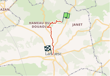

Length
5.7 km

Max alt
367 m

Uphill gradient
21 m
Km-Effort
6.5 km

Min alt
197 m

Downhill gradient
178 m
Boucle
No
Creation date :
2024-02-17 14:36:55.0
Updated on :
2024-02-17 15:51:12.221

FREE GPS app for hiking
 SityTrail
IGN / Geographical institutes
SityTrail Plus
The world is yours!
About
Trail of 5.7 km to be discovered at Provence-Alpes-Côte d'Azur, Bouches-du-Rhône, Lambesc. This trail is proposed by didierc13.
Description
À travers les vignes
Positioning
Country:
France
Region :
Provence-Alpes-Côte d'Azur
Department/Province :
Bouches-du-Rhône
Municipality :
Lambesc
Location:
Unknown
Start:(Dec)
Start:(UTM)
683172 ; 4838818 (31T) N.
Comments