


RD-Longechenal-Le Grand Liers

raymondfn
User
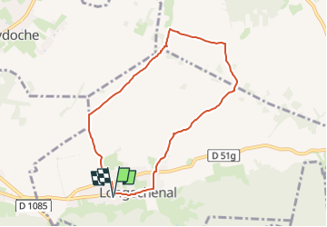

Length
7.5 km

Max alt
541 m

Uphill gradient
51 m
Km-Effort
8.2 km

Min alt
497 m

Downhill gradient
51 m
Boucle
Yes
Creation date :
2024-02-18 12:24:06.227
Updated on :
2024-02-18 12:33:19.29
1h51
Difficulty : Medium

FREE GPS app for hiking
 SityTrail
IGN / Geographical institutes
SityTrail Plus
The world is yours!
About
Trail Walking of 7.5 km to be discovered at Auvergne-Rhône-Alpes, Isère, Longechenal. This trail is proposed by raymondfn.
Positioning
Country:
France
Region :
Auvergne-Rhône-Alpes
Department/Province :
Isère
Municipality :
Longechenal
Location:
Unknown
Start:(Dec)
Start:(UTM)
683665 ; 5032057 (31T) N.
Comments