


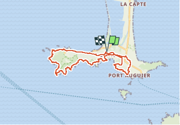
Presqu’île de Giens

GeorgesV.
User

Length
18 km

Max alt
95 m

Uphill gradient
532 m
Km-Effort
25 km

Min alt
0 m

Downhill gradient
533 m
Boucle
Yes
Creation date :
2024-02-18 07:41:53.0
Updated on :
2024-03-03 19:37:01.686
5h42
Difficulty : Very difficult

FREE GPS app for hiking
 SityTrail
IGN / Geographical institutes
SityTrail Plus
The world is yours!
About
Trail Walking of 18 km to be discovered at Provence-Alpes-Côte d'Azur, Var, Hyères. This trail is proposed by GeorgesV..
Description
Randonnée sur le pourtour de la presqu’île de Giens en suivant une partie du sentier littoral. Parcours difficile compte tenu des nombreuses côtes et descentes avec de bonnes pentes.
Positioning
Country:
France
Region :
Provence-Alpes-Côte d'Azur
Department/Province :
Var
Municipality :
Hyères
Location:
Unknown
Start:(Dec)
Start:(UTM)
266338 ; 4769210 (32T) N.
Comments