


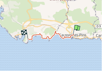
Sausset les pins Cap Couronne

portefaix
User

Length
7 km

Max alt
26 m

Uphill gradient
67 m
Km-Effort
8 km

Min alt
0 m

Downhill gradient
85 m
Boucle
No
Creation date :
2024-02-18 16:06:27.657
Updated on :
2024-02-18 16:08:01.807
1h48
Difficulty : Easy
1h48
Difficulty : Medium
0m
Difficulty : Very easy

FREE GPS app for hiking
 SityTrail
IGN / Geographical institutes
SityTrail Plus
The world is yours!
About
Trail On foot of 7 km to be discovered at Provence-Alpes-Côte d'Azur, Bouches-du-Rhône, Sausset-les-Pins. This trail is proposed by portefaix.
Description
Tracé depuis la gare de Sausset pour une rando en aller retour sur le sentier des douaniers
Positioning
Country:
France
Region :
Provence-Alpes-Côte d'Azur
Department/Province :
Bouches-du-Rhône
Municipality :
Sausset-les-Pins
Location:
Unknown
Start:(Dec)
Start:(UTM)
671050 ; 4799927 (31T) N.
Comments