Trail Walking Chaux-Neuve - 2024-02-19_10h54m37_visorando-vue-sur-le-haut-du-tremplin-de-chaux-neuve-et-la-cascade-du-bief-bridaux - Photo

2024-02-19_10h54m37_visorando-vue-sur-le-haut-du-tremplin-de-chaux-neuve-et-la-cascade-du-bief-bridaux

© OpenStreetMap contributors
Length
Length
9.1 km
Max alt
Max alt
1158 m
Uphill gradient
Uphill gradient
253 m
Km-Effort
Km-Effort  
12.5 km
Min alt
Min alt
991 m
Downhill gradient
Downhill gradient
254 m
Boucle
Boucle
Yes
Creation date :
2024-02-19 09:54:37.914
Updated on :
2024-02-23 15:17:44.542

(1 Reviews)

Walking
Walking
2h50
Difficulty : Difficult

Scan this QR Code to open this trail in the SityTrail application

FREE GPS app for hiking

Logo SityTrail SityTrail

IGN / Geographical institutes

Download SityTrail from the App Store Download SityTrail from Google Play

Logo SityTrail SityTrail World

The world is yours!

Download SityTrail from the App Store Download SityTrail from Google Play Download SityTrail on Huawei AppGallery

About

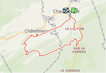
Trail Walking of 9.1 km to be discovered at Bourgogne-Franche-Comté, Doubs, Chaux-Neuve. This trail is proposed by daniellebou.

Description

Importé de Visorando.
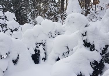
Boucle qui vous fera découvrir le point de vue de la Roche Blanche avec sa Vierge. Panorama à 360°, à l'Est vue sur Châtelblanc et le Val de Mouthe; à l'Ouest vue sur le Val de Foncine ; au Sud l'immense forêt du Noirmont et au Nord vue sur les Cabouilles, la Combette, la Vernouge et le Mont Croz. Puis la cascade du Bief Bridaux par un sentier très étroit (il faudra être vigilant) , et le haut du tremplin de Chaux-Neuve par de beaux sentier. Retour en forêt.

Elevation profile

Photos

Positioning

Country:
France
Region :
Bourgogne-Franche-Comté
Department/Province :
Doubs
Municipality :
Chaux-Neuve
Location:
Unknown
Start:(UTM)
280901 ; 5173385 (32T) N.

Comments

Please log in to post a review or rate the element


Trails nearby

Trail Walking Mouthe - Mouthe - La Source du Doubs - Photo
Walking
bmorel@orange.fr

Walking

Very easy
(1)
Mouthe, Bourgogne-Franche-Comté, Doubs, France
5.4 km | 6.5 km-effort
Unknown
Yes
Trail Walking Châtelblanc - Le pré-poncet par le petit pont et la forêt  - Photo
Walking
fizz1212

Walking

Medium
Châtelblanc, Bourgogne-Franche-Comté, Doubs, France
5.9 km | 7.7 km-effort
1h 44min
Yes
Trail On foot Mouthe - Les Roches - Photo
On foot
PRO

On foot

Easy
Mouthe, Bourgogne-Franche-Comté, Doubs, France
4.2 km | 6.1 km-effort
1h 23min
Yes
Trail Walking Foncine-le-Haut - Sur les hauteurs de Foncine - Photo
Walking
cmike39

Walking

Very easy
(1)
Foncine-le-Haut, Bourgogne-Franche-Comté, Jura, France
13.5 km | 18.2 km-effort
3h 58min
Yes
Trail Mountain bike Foncine-le-Haut - Grandes Traversées du Jura à VTT - Haut Jura - Photo
Mountain bike
tracegps

Mountain bike

Very difficult
Foncine-le-Haut, Bourgogne-Franche-Comté, Jura, France
84 km | 110 km-effort
7h 30min
No
Trail Walking Foncine-le-Haut - GTJ 5 Foncine le Haut, Chapelle des Bois  - Photo
Walking
Praff

Walking

Easy
Foncine-le-Haut, Bourgogne-Franche-Comté, Jura, France
12.8 km | 17.8 km-effort
4h 7min
No
Trail Walking Mouthe - GTJ 4 Mouthe, Foncine le Haut - Photo
Walking
Praff

Walking

Medium
Mouthe, Bourgogne-Franche-Comté, Doubs, France
28 km | 39 km-effort
7h 12min
No
Trail Snowshoes Châtelblanc - raquette jeudi jura - Photo
Snowshoes
Thierry Lalouze

Snowshoes

Medium
Châtelblanc, Bourgogne-Franche-Comté, Doubs, France
11.8 km | 15.5 km-effort
3h 55min
Yes
Trail Snowshoes Châtelblanc - raquette jura j2 - Photo
Snowshoes
Thierry Lalouze

Snowshoes

Easy
Châtelblanc, Bourgogne-Franche-Comté, Doubs, France
9.6 km | 13.2 km-effort
2h 53min
No


Close
My subscriptions