


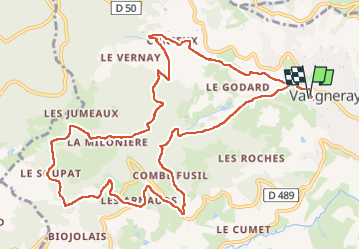
Vaugneray (13 km - D. 566 m)

Thomasdanielle
User

Length
13.5 km

Max alt
705 m

Uphill gradient
566 m
Km-Effort
21 km

Min alt
394 m

Downhill gradient
565 m
Boucle
Yes
Creation date :
2024-02-19 08:35:59.0
Updated on :
2024-03-15 09:28:10.046
4h46
Difficulty : Very difficult

FREE GPS app for hiking
 SityTrail
IGN / Geographical institutes
SityTrail Plus
The world is yours!
About
Trail Walking of 13.5 km to be discovered at Auvergne-Rhône-Alpes, Rhône, Vaugneray. This trail is proposed by Thomasdanielle.
Description
D/A : Parking des randonneurs
Positioning
Country:
France
Region :
Auvergne-Rhône-Alpes
Department/Province :
Rhône
Municipality :
Vaugneray
Location:
Vaugneray
Start:(Dec)
Start:(UTM)
628759 ; 5066193 (31T) N.
Comments