


les eygoires- pierre arnoux

jiam6852
User
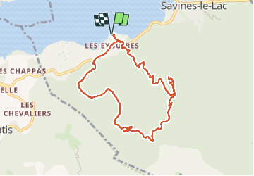

Length
9.6 km

Max alt
1395 m

Uphill gradient
628 m
Km-Effort
18 km

Min alt
783 m

Downhill gradient
629 m
Boucle
Yes
Creation date :
2024-02-19 09:44:22.713
Updated on :
2024-02-19 15:27:29.044
3h39
Difficulty : Difficult

FREE GPS app for hiking
 SityTrail
IGN / Geographical institutes
SityTrail Plus
The world is yours!
About
Trail Walking of 9.6 km to be discovered at Provence-Alpes-Côte d'Azur, Hautes-Alpes, Savines-le-Lac. This trail is proposed by jiam6852.
Positioning
Country:
France
Region :
Provence-Alpes-Côte d'Azur
Department/Province :
Hautes-Alpes
Municipality :
Savines-le-Lac
Location:
Unknown
Start:(Dec)
Start:(UTM)
292176 ; 4933026 (32T) N.
Comments