


Brugelette

mozzipsc
User
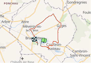

Length
11.5 km

Max alt
72 m

Uphill gradient
95 m
Km-Effort
12.8 km

Min alt
40 m

Downhill gradient
100 m
Boucle
No
Creation date :
2015-03-25 00:00:00.0
Updated on :
2015-03-25 00:00:00.0
2h21
Difficulty : Easy

FREE GPS app for hiking
 SityTrail
IGN / Geographical institutes
SityTrail Plus
The world is yours!
About
Trail Walking of 11.5 km to be discovered at Wallonia, Hainaut, Brugelette. This trail is proposed by mozzipsc.
Description
Joli petit parcours entre ruisseaux et campagne aux portes de Pairi Daiza.
Positioning
Country:
Belgium
Region :
Wallonia
Department/Province :
Hainaut
Municipality :
Brugelette
Location:
Brugelette (section)
Start:(Dec)
Start:(UTM)
561058 ; 5604500 (31U) N.
Comments