


Bases avec groupe

crognon
User
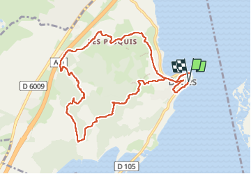

Length
11.3 km

Max alt
93 m

Uphill gradient
268 m
Km-Effort
14.8 km

Min alt
0 m

Downhill gradient
273 m
Boucle
Yes
Creation date :
2024-01-28 08:44:55.286
Updated on :
2024-02-19 17:40:42.384
5h10
Difficulty : Easy

FREE GPS app for hiking
 SityTrail
IGN / Geographical institutes
SityTrail Plus
The world is yours!
About
Trail Walking of 11.3 km to be discovered at Occitania, Aude, Bages. This trail is proposed by crognon.
Positioning
Country:
France
Region :
Occitania
Department/Province :
Aude
Municipality :
Bages
Location:
Unknown
Start:(Dec)
Start:(UTM)
499517 ; 4774545 (31T) N.
Comments