


les chabrands

Roger
User

Length
8.3 km

Max alt
529 m

Uphill gradient
164 m
Km-Effort
10.5 km

Min alt
385 m

Downhill gradient
168 m
Boucle
Yes
Creation date :
2024-02-20 12:59:26.195
Updated on :
2024-02-20 15:55:33.29
2h55
Difficulty : Easy

FREE GPS app for hiking
 SityTrail
IGN / Geographical institutes
SityTrail Plus
The world is yours!
About
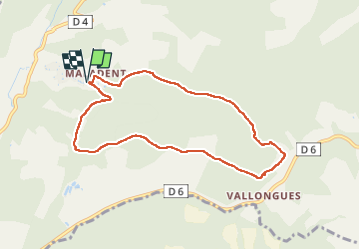
Trail Walking of 8.3 km to be discovered at Provence-Alpes-Côte d'Azur, Alpes-de-Haute-Provence, Valensole. This trail is proposed by Roger .
Positioning
Country:
France
Region :
Provence-Alpes-Côte d'Azur
Department/Province :
Alpes-de-Haute-Provence
Municipality :
Valensole
Location:
Unknown
Start:(Dec)
Start:(UTM)
730264 ; 4855987 (31T) N.
Comments