


Montreuil Juigné

bubuserge
User
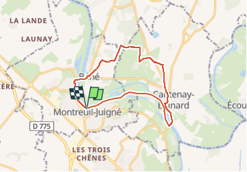

Length
12.9 km

Max alt
60 m

Uphill gradient
100 m
Km-Effort
14.3 km

Min alt
11 m

Downhill gradient
109 m
Boucle
Yes
Creation date :
2024-02-20 13:09:22.0
Updated on :
2024-02-28 18:04:05.449
3h14
Difficulty : Difficult

FREE GPS app for hiking
 SityTrail
IGN / Geographical institutes
SityTrail Plus
The world is yours!
About
Trail Walking of 12.9 km to be discovered at Pays de la Loire, Maine-et-Loire, Montreuil-Juigné. This trail is proposed by bubuserge.
Positioning
Country:
France
Region :
Pays de la Loire
Department/Province :
Maine-et-Loire
Municipality :
Montreuil-Juigné
Location:
Unknown
Start:(Dec)
Start:(UTM)
679891 ; 5266840 (30T) N.
Comments