


Montrond

Mariolebeno
User
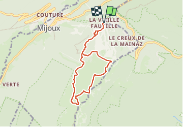

Length
7 km

Max alt
1583 m

Uphill gradient
352 m
Km-Effort
11.7 km

Min alt
1317 m

Downhill gradient
352 m
Boucle
Yes
Creation date :
2024-02-20 21:10:56.299
Updated on :
2024-02-20 21:10:57.605
2h39
Difficulty : Medium

FREE GPS app for hiking
 SityTrail
IGN / Geographical institutes
SityTrail Plus
The world is yours!
About
Trail Walking of 7 km to be discovered at Auvergne-Rhône-Alpes, Ain, Mijoux. This trail is proposed by Mariolebeno.
Positioning
Country:
France
Region :
Auvergne-Rhône-Alpes
Department/Province :
Ain
Municipality :
Mijoux
Location:
Unknown
Start:(Dec)
Start:(UTM)
270396 ; 5139214 (32T) N.
Comments