


bruyant lans en v

bymarc26
User
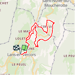

Length
21 km

Max alt
1308 m

Uphill gradient
706 m
Km-Effort
30 km

Min alt
907 m

Downhill gradient
707 m
Boucle
Yes
Creation date :
2015-03-14 00:00:00.0
Updated on :
2015-03-14 00:00:00.0
7h14
Difficulty : Unknown

FREE GPS app for hiking
 SityTrail
IGN / Geographical institutes
SityTrail Plus
The world is yours!
About
Trail Walking of 21 km to be discovered at Auvergne-Rhône-Alpes, Isère, Lans-en-Vercors. This trail is proposed by bymarc26.
Positioning
Country:
France
Region :
Auvergne-Rhône-Alpes
Department/Province :
Isère
Municipality :
Lans-en-Vercors
Location:
Unknown
Start:(Dec)
Start:(UTM)
703549 ; 5000440 (31T) N.
Comments