


ambronay 2

robert gallet
User
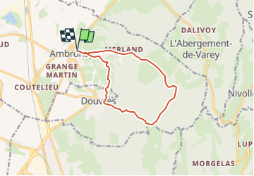

Length
11.4 km

Max alt
532 m

Uphill gradient
368 m
Km-Effort
16.3 km

Min alt
275 m

Downhill gradient
366 m
Boucle
Yes
Creation date :
2024-02-22 19:44:11.859
Updated on :
2024-02-22 19:44:42.244
3h42
Difficulty : Difficult

FREE GPS app for hiking
 SityTrail
IGN / Geographical institutes
SityTrail Plus
The world is yours!
About
Trail Walking of 11.4 km to be discovered at Auvergne-Rhône-Alpes, Ain, Ambronay. This trail is proposed by robert gallet.
Positioning
Country:
France
Region :
Auvergne-Rhône-Alpes
Department/Province :
Ain
Municipality :
Ambronay
Location:
Unknown
Start:(Dec)
Start:(UTM)
682961 ; 5097439 (31T) N.
Comments